
Undergraduate Research Spotlight: Mapping the World with the Latest Technology
In today’s rapidly evolving world, geospatial technologies such as GIS, UAVs, and LiDAR are transforming the way we understand and interact with our environment. For students looking to make their mark in the field of mapping and surveying, there has never been a more exciting time to dive into research that tackles real-world challenges using cutting-edge tools. From climate change mitigation to smart city planning, undergraduate research projects can now contribute directly to global solutions.
This spotlight introduces a range of innovative thesis ideas that leverage the latest advancements in geospatial technology. Whether you are interested in urban planning, environmental conservation, or disaster management, these research ideas are designed to inspire and guide you as you embark on your undergraduate thesis journey. Explore the potential of modern mapping tools to address some of the world’s most pressing issues and become part of the next generation of geospatial innovators.
Start exploring now and discover how you can make an impact with the power of mapping technologies!
Overview: This research could explore how LiDAR-equipped drones (UAVs) are used to map forest biomass and carbon stocks, a critical component in addressing climate change. The study could focus on forest conservation, reforestation efforts, or deforestation monitoring in tropical regions like Southeast Asia or the Amazon.
Technology: UAVs, LiDAR sensors, GIS for spatial analysis.
Global Issue: Climate change and deforestation.

Overview: The research would focus on how GIS and machine learning algorithms can be used to map and predict urban heat islands (UHI) in rapidly growing cities. The goal is to understand the spatial patterns of heat intensity and propose mitigation strategies based on the findings.
Technology: GIS, machine learning, remote sensing.
Global Issue: Urbanization and climate resilience.

Overview : This research could analyse coastal erosion patterns using satellite imagery and GIS techniques, providing essential data to manage and mitigate erosion in vulnerable coastal areas. The focus could be on creating a GIS-based early warning system or evaluating existing coastal defense mechanisms.
Technology: Remote sensing (e.g., Sentinel-2, Landsat), GIS.
Global Issue: Coastal erosion, sea-level rise, and climate change.

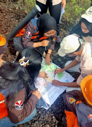
Overview: Examine how participatory mapping (e.g., OpenStreetMap) and crowdsourced geospatial data can enhance disaster preparedness and emergency response, particularly during earthquakes or floods. The study could evaluate how such data complements official sources in crisis situations.
Technology: GIS, crowdsourced mapping platforms, participatory mapping.
Global Issue: Disaster management and resilience.

Overview: This study would use GIS to identify areas with limited access to fresh, affordable food—commonly known as food deserts. The research could explore spatial relationships between socio-economic status and food access, providing insights for policymakers.
Technology: GIS, spatial analysis.
Global Issue: Food security, urban planning, public health.

Overview: Research the integration of GIS with Internet of Things (IoT) sensors to manage traffic congestion in urban areas. The study could include real-time data collection from traffic sensors and develop GIS-based solutions for optimizing traffic flow.
Technology: GIS, IoT, real-time traffic monitoring.
Global Issue: Urban mobility, traffic congestion.

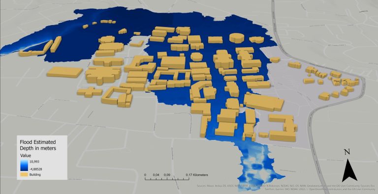
Overview: Focus on assessing urban flood risks using GIS combined with remote sensing data. The research can investigate how spatial data helps identify flood-prone zones and improve city resilience through flood hazard maps.
Technology: GIS, remote sensing (e.g., DEM data, satellite imagery).
Global Issue: Flood risk management, urban resilience.

Overview: This research would use GIS to conduct land suitability analysis for sustainable agriculture in semi-arid regions. By incorporating climate, soil, and water availability data, the study could provide insights into optimizing land use for agriculture in regions vulnerable to climate change.
Technology: GIS, spatial analysis, remote sensing.
Global Issue: Sustainable agriculture, food security.

Overview: The research would explore how 3D city models developed using GIS and Building Information Modeling (BIM) can assist in urban planning, infrastructure development, and environmental impact assessments. This is particularly relevant for smart city development.
Technology: GIS, BIM, 3D modeling.
Global Issue: Urbanization, smart cities.
Overview: This study could focus on the spatial analysis of wildfire damage using remote sensing data and GIS. It could assess the impact of fires on vegetation and wildlife and provide recommendations for better forest management and fire prevention strategies.
Technology: GIS, remote sensing, fire modeling tools.
Global Issue: Wildfires, environmental degradation.
These topics offer a combination of cutting-edge technology and real-world problems, providing opportunities to address global challenges while leveraging the latest in GIS, surveying, and mapping technologies.
As you explore these innovative research ideas, remember that guidance from an expert can greatly enhance your project. We encourage you to reach out to lecturers and faculty members whose expertise aligns with your chosen topic. They can provide valuable insights, help refine your thesis direction, and connect you with the latest research and resources in GIS, mapping, and surveying technologies.
Whether you’re interested in environmental applications, urban development, or cutting-edge technology, your lecturers are here to support you every step of the way. Don’t hesitate to seek their advice to ensure your undergraduate research project makes a meaningful contribution to the field!